By Jim Parker, Ph.D.
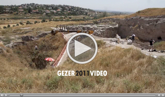
The 2011 Gezer dig officially ended on June 10 with much celebration. As has been reported previously, we were able to get to the cave and even a little beyond. Getting to the cave turned out to be quite a feat and was a great challenge to us all. Although I will say more in this report about the statistics related to the dig, we took out 1,372 bags (one cubic meter bags designed for lifting sand, etc) in 17 days of work. Although our low day was 32 bags, we also had a day when we removed 129 bags. All in all, we averaged about 80 bags per day. Of course each bag was far less than one cubic meter, as the crane would not have been able to lift them.
One of the great challenges we have faced as we have dug at Gezer in 2010 and 2011 is to interpret the data of the two archaeologists that preceded us. Although both were erudite men, well accomplished in their discipline for the era in which they worked, both have left us with information that sometimes is difficult, if not impossible, to discern. I thought as we considered the dig for this year, it would be good to go back to the beginning and discuss the contributions that Robert Alexander Stewart Macalister and Fr. Hugues Pere Vincent (pronounced “Vinsant” in French) made to the Gezer Water tunnel and also to discuss the complex issues we have inherited from them. This will hopefully help in understanding this magnificent, ancient edifice presumably left to us by the Canaanites from the days of the biblical Patriarchs.
R.A.S. Macalister (Macalister) was an Irish archaeologist who studied at Cambridge and arrived in Palestine around 1898 at the age of 28 years old. He worked with Frederick J. Bliss using the stratigraphic methods of Sir Flinders Petrie. These methods were far advanced to the techniques previously used. He and Bliss also used pottery that they unearthed to develop a chronology for Palestine, especially the Shephelah.
Macalister came to the ancient Canaanite city of Tel Gezer in 1902 and labored there until 1909. He worked under the auspices of the Palestinian Exploration Fund and made quarterly reports of his work at Gezer, which were published in the Palestinian Exploration Quarterly (PEQ). It is these reports that have been most helpful to us in our work. I used dimensions from them in 2008 to construct a drawing for us to work from as we formulated our plan. Macalister also published a drawing of the Water Tunnel in these reports. As a general note, although far superior to the “cut and slash” archaeological methods earlier employed, Macalister has been roundly criticized in modern times for the poor quality of excavations and his less than adequate record keeping. Some of this may have been due to his age (32-39 years old while at Gezer) and his lack of help. At Gezer, Macalister was the only archaeologist on the dig. In fact, Macalister, by his own reporting was the only person other than the cook and the Arab excavators. Apparently the budget for the excavation was very tight and the Arab excavators worked for “bakhshish”, the practice of paying them for their finds. This likely led to a “treasure hunt” mentality rather than a slow and deliberate excavation methodology.
Macalister first mentioned the Water Tunnel in the 16th Quarterly Report of the PEQ. The report is for the work done between Aug. 11 and Nov. 9, 1907. He describes in great detail how he happened to find the water system and the work that went on to clear it. It is assumed that his find coincides with the earlier date, probably in the late summer or early fall of 1907. In the 16th Report, he tells how his team cleared the tunnel little by little, uncovering the immense 12’-6” wide by 23’-10 tall arched tunnel that plunges down at an amazing 38 degree angle 150 feet to a natural cave (at least Macalister thought it was natural). There are 80 steps, carved from the Eocene chalk rock in the tunnel. At the end of the steps, Macalister described what is likely the spring; an area that is as wide as the tunnel and approximately 30 feet long that leads into the cave. It is still uncertain whether this water source extends partially or fully into the cave. Macalister also described how that he cut a trench around the outer edges of the cave and then one down the middle to try and ascertain the nature of the cave and whether there was an exit. Macalister said that he did not find an exit, however, Vincent, who published a drawing of the tunnel in 1912, shows what could be an exit, an area at the rear of the tunnel that has been blocked up with stones.

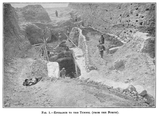
Macalister provided this photograph showing the upper entrance to the tunnel. Steps led down approximately 25 feet below the top of the bedrock and then one would turn left underground and down into the tunnel. Note the solid wall of dirt (balk) on the right and the rock retaining walls that
have been constructed to hold back this wall of dirt and to keep anything out of the tunnel. In the 17th Quarterly report that covered the work from November 11, 1907 until February 10, 1908, Macalister reported that much of this wall of dirt and a large portion of the retaining walls collapsed during a powerful storm on January 20, 1908 substantially refilling the tunnel. Due to financial considerations, he decided to suspend work on the tunnel and moved on. He would complete the balance of the work on Tel Gezer within the year.
I mentioned Fr. Vincent earlier. An article written by him is included in the 18th Quarterly Report for the period Feb. 11 through May 9, 1908. Apparently Vincent visited the site prior to the above mentioned collapse. The reason that I feel so sure of this is that Vincent gives details on his drawing, (dated in 1912, four years after the collapse) which in reference to the cave is substantially different from Macalister’s drawing. He also gives details that Macalister does not. For instance, Vincent limits the water source to the area between the bottom step and the cave entrance. He also shows on his drawing that the cave is 20 meters long (66 feet), however, he shows large rocks at the back as if it has been blocked up. Macalister shows the cave at 25 meters (80 feet), but shows the walls to be solid with no exit. Vincent also shows the cave entrance turning dramatically left, Macalister shows his going straight.
What does one make of all of this? Well this is the reason for our excavation, to try and find answers to these and a myriad of questions that we have and that will present themselves as we progress. Some of these types of issues with Macalister’s and Vincent’s narratives and drawings are part of the challenges that we have encountered. For instance, based on information that both gave, we would have expected to hit the entrance to the cave approximately 15 feet before we did. This was significant because we were digging an area 11 feet wide by 7 feet high. Every foot required 30 more bags that we had to dig and pull up and out in order for us to move down the tunnel. This added a total of 450 bags or about six days of work beyond what we anticipated.
Jim Parker, Ph.D., is Associate Professor of Biblical Interpretation and Associate Vice President of Facilities at New Orleans Baptist Theological Seminary.
--
The Gezer Water System project is co-sponsored by the Israel Nature and Parks Authority and New Orleans Baptist Theological Seminary under the direction of Tsvika Tsuk, chief archaeologist at INPA, and Dan Warner, co-director of the Center for Archaeological Research at NOBTS.